Page 5 The Separation Barrier, The Wall.
If you travel with a standard
tour, going to the places that Israel
thinks of as "safe" and proper for tourists, you may well not become
aware of the current problems. In an attempt to reduce suicide
bombings - an effort which has been considerably successful, Israel has
been building a "separation barrier" - which is sometimes a wall and
sometimes a complex of multiple fences - to separate Israelis and
Palestinians in the territories occupied since 1967.
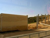
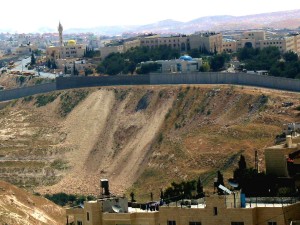
Here we see some of the wall under construction. Where it
runs along a highway used by Israelis, it often appears
rather like the sound barrier walls along superhighways in the United
States. Where it snakes between Palestinian neighborhoods. As it does
for
example on the edges of the city limits of East Jerusalem, it can be
much more unattractive and often gets the same sort of
graffiti that used to be on the wall around West Berlin.
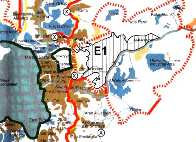
The wall does not run along the old 1948 borders. Now, quite
frankly, the 1948 to 1967 borders were a bit bizarre. The line
snaked through the city of Jerusalem, even with enclaves that did not
connect. Here is a map just showing the Jerusalem area
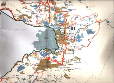
You can see the old line in green, some of the new barrier in red, and
proposed or under-construction barrier places in dotted red - many of
those were done when we were there. Note how far east the
proposed additions are - all the way into the desert area of Judea,
which
effectively cuts any North-South roads for the Palestinians.
You can see how close in Bethlehem is, the brown area south of the
center.
I do feel sorry for the poor city planners of Jerusalem. It is natural
to want suburbs- but you know that some day there will be a border, and
have no idea where it will be, or when.
 Let's look at a blow-up close to the center of Jerusalem.
Brown shows the Palestinian areas, blue shows the Jewish ones.
The
Old City is the white block just next to the old green line; the green
block northeast of it is an Israeli enclave surrounded by the
Jordanians from 1948 to 1967, containing the old hospital and
university built by the Jews prior to 1948.
Can you see Abu Tor, just south of the Old City? During 1948 to
1967 the Jordanians did not allow the Palestinians to have
universities. When Israel took over in 1967, it allowed the
establishment of Palestinian Universities. Al Kuds University, the
Palestinian University in Jerusalem - it helps if you know that the
city is called Al Kuds in Arabic - has its main campus at Abu
Tor.
 When the wall was built
around the "new" city limits of
Jerusalem, it left the campus outside - cutting it off from most of its
students.
When the wall was built
around the "new" city limits of
Jerusalem, it left the campus outside - cutting it off from most of its
students.
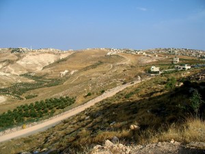
One feature of the wall around Jerusalem is how often it separates a
village from its agricultural fields. In some cases, as to the right,
the idea
is to leave open space for Jerusalem to grow into, without including
the Palestinian population.
In other cases, the people demanded to be included in Jerusalem and
Israel
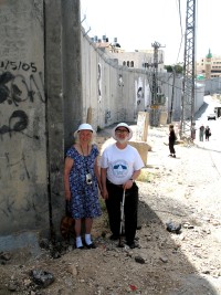
agreed, but left out the fields. Below is a picture at Sur Bahir on the
eastern outskirts of
Jerusalem; we stood with a villager behind his house, and could see his
olive trees, but he can't get to them
without going many miles to a crossing point.
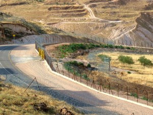
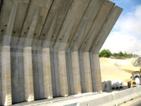
To the right you see the structure of the barrier: razor
wire on both
sides of an army patrol road, electrified fence on one side.
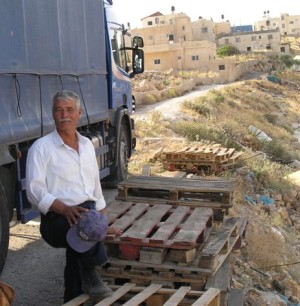
Here is the man who owns the olive trees but cannot get to them. He is
actually rather well off - he is a schoolteacher in Jerusalem, teaching
mathematics, so he gets paid by the Israeli government. He has managed
to send his sons to college. The truck belongs to one of his
sons, who has a business delivering bottled water - many of the
Palestinian neighborhoods have little or no good water supply.
Here is a small portion of a UN
map showing some of the area around Hebron
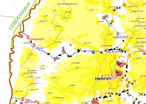
The black triangles denote "Earth mounds" - most often where a cross
street has been blocked so that Palestinians cannot enter or cross a
road used by Israelis. The white areas are reserved for Israelis or the
Israeli military, to ensure security or to allow Israelis to go to and
from the settlements, such as the ones shown in red near Hebron. The
effect is to cut the West Bank up into small areas, and it is very
difficult for Palestinians to travel from one small area to another.
The announced intent is to have a system of bridges and tunnels
so that the Palestinian areas interconnect, but there is little visible
progress on that. Some Palestinians, the ones who have learned
enough Jewish history, compare the Palestinian areas to the ghettos in
which the Jews were often confined in Europe.
I am unconvinced that any amount of "separation" is really a
cure. While I'll talk elsewhere about the need for a functioning
Palestinian economy, It is essential to stress how close these
places are to one another. Here, taken from the web, is a photo
taken by a peace group. They are standing on a hill in the West Bank -
clearly Palestinian territory. And when you look down, you see downtown
Tel Aviv in the distance.
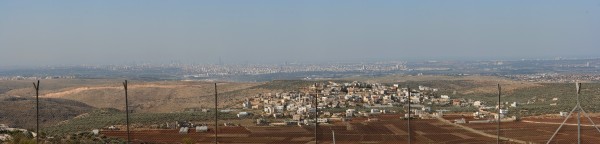
Here is an enlargement of the center portion:
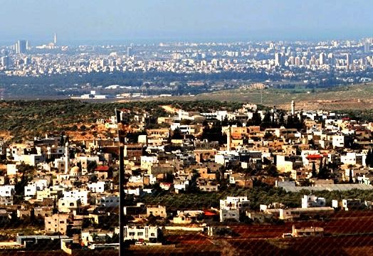
Keeping the Palestinians subjugated is at most a short-term
solution. Very short-term, as is known from the rockets crossing
the borders from time to time on the Gaza and Lebanese borders. I
can understand Israel not wanting rocket launchers on this hilltop.
What is needed is a way to live together in peace.
>NEXT PAGE
Ordman Net Home
Israel/Palestine Info Home
CONTENTS:
Page 1: Introduction
Page 2: Kfar Shalem
Page 3: Duheisha Refugee Camp
Page 4: Universities
Page 5: The Wall / Security Barrier
Next > Page 6: Bethlehem
Page 7: Efrat
Page 8: Hebron
(More to come)